
Файл:Divided Yemen.svg

Розмір цього попереднього перегляду PNG для вихідного SVG-файлу: 800 × 483 пікселів. Інші роздільності: 320 × 193 пікселів | 640 × 386 пікселів | 1024 × 618 пікселів | 1280 × 772 пікселів | 2560 × 1544 пікселів | 1210 × 730 пікселів.
Повна роздільність (SVG-файл, номінально 1210 × 730 пікселів, розмір файлу: 71 КБ)
| Відомості про цей файл містяться на ВікіСховищі, централізованому сховищі вільно розповсюджуваних зображень та мультимедіа для використання у проектах Фонду Вікімедіа. |

|
Цей SVG-файл містить вкладений текст, який може бути легко перекладений Вашою мовою за допомогою інструменту SVG Translate або будь-якого редактора SVG. Дізнайтесь більше про переклад SVG-файлів. |
Опис файлу
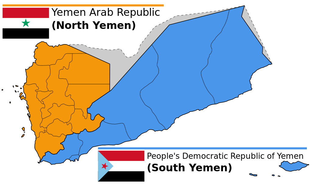
| Опис |
English: Map of North and South Yemen prior to unification.
Español: Yemen previo a la unificación, en 1990.
Français : Le Yémen avant l'unification.
Português: Iêmen do Norte (em laranja) e Iêmen do Sul (em azul) antes de 1990. |
| Час створення | (UTC) |
| Джерело | |
| Автор |
|
| Інші версії |
|


.svg)


Ліцензування
Цей файл ліцензований на умовах Creative Commons Attribution-Share Alike 3.0 Unported
- Ви можете вільно:
- ділитися – копіювати, поширювати і передавати твір
- модифікувати – переробляти твір
- При дотриманні таких умов:
- зазначення авторства – Ви повинні вказати авторство, надати посилання на ліцензію і вказати, чи якісь зміни було внесено до оригінального твору. Ви можете зробити це в будь-який розсудливий спосіб, але так, щоб він жодним чином не натякав на те, наче ліцензіар підтримує Вас чи Ваш спосіб використання твору.
- поширення на тих же умовах – Якщо ви змінюєте, перетворюєте або створюєте іншу похідну роботу на основі цього твору, ви можете поширювати отриманий у результаті твір тільки на умовах такої ж або сумісної ліцензії.
Журнал завантажень локального файлу
This image is a derivative work of the following images:
- File:Map_of_North_and_South_Yemen.png licensed with Cc-by-sa-3.0, GFDL
- 2011-03-21T17:54:35Z Orange Tuesday 1600x1024 (63249 Bytes) 1600 px wide
- 2011-03-21T17:51:50Z Orange Tuesday 1598x1024 (63069 Bytes) {{Information |Description ={{en|1=Map of North and South Yemen prior to unification.}} |Source ={{own}} |Author =[[User:Orange Tuesday|Orange Tuesday]] |Date = |Permission = |other_versions =
- File:Flag_of_North_Yemen.svg licensed with PD-shape
- 2011-08-22T05:56:53Z Alkari 900x600 (731 Bytes) code cleanup; star precision; file size
- 2010-06-27T03:28:25Z Fry1989 900x600 (2295 Bytes) red
- 2006-01-17T05:29:39Z B1mbo 900x600 (665 Bytes) Few corrections
- 2006-01-17T05:15:33Z B1mbo 900x600 (1963 Bytes) == Sumario == {{en|Flag of the [[:en:Yemen Arab Republic|Yemen Arab Republic (North Yemen)]] (1962-1990)}} {{es|Bandera de la [[:es:Yemen del Norte|República Árabe de Yemen (Yemen del Norte)]] (1962-1990)}} [[Category:Flag
- File:Flag_of_South_Yemen.svg licensed with PD-self
- 2011-08-22T06:02:04Z Alkari 1800x1200 (804 Bytes) code cleanup; star precision
- 2010-06-27T03:26:35Z Fry1989 1800x1200 (2702 Bytes) shades
- 2006-01-08T18:55:08Z Dbenbenn 1800x1200 (946 Bytes) by me, PD. Based on https://www.fotw.info/flags/ye-south.html
- 2006-01-04T23:52:54Z Chanheigeorge 195x130 (3741 Bytes) Converted from Image:South_Yemen_Flag.PNG
- File:Governorates_of_Yemen_named.svg licensed with Cc-by-sa-2.5,2.0,1.0, Cc-by-sa-3.0-migrated, GFDL
- 2007-05-23T17:35:54Z Jarke 1208x719 (77247 Bytes) == Sumario == {{Information |Description={{en|Governorates of Yemen, after 2004}} {{es|Governaciones de Yemen, después del 2004}} |Source=SVG version of [[:Image:Yemen governorates numbered english.png]] and [[:Imagen:Yemen
Uploaded with derivativeFX
Історія файлу
Клацніть на дату/час, щоб переглянути, як тоді виглядав файл.
| Дата/час | Мініатюра | Розмір об'єкта | Користувач | Коментар | |
|---|---|---|---|---|---|
| поточний | 14:58, 20 грудня 2023 | | 1210 × 730 (71 КБ) | אורי9 | File uploaded using svgtranslate tool (https://svgtranslate.toolforge.org/). Added translation for he. |
| 19:47, 8 листопада 2020 |  | 1210 × 730 (71 КБ) | Panam2014 | Reverted to version as of 18:27, 8 July 2019 (UTC) | |
| 08:46, 9 серпня 2020 |  | 1210 × 730 (44 КБ) | AlMahra67 | text | |
| 18:05, 3 серпня 2020 |  | 1210 × 730 (39 КБ) | AlMahra67 | Changed dimensions | |
| 17:50, 3 серпня 2020 |  | 512 × 309 (39 КБ) | AlMahra67 | If this map is supposed to show South and North Yemen division currently then it should be like this. The current divisions are based on the former divisions between the North and South Yemen. The previous version showed the new administrative boundaries that were created after unity. The new administrative boundary split areas that were part of the south. For example Dhale and Mukayras are shown as part of the North when they are in fact Southern. | |
| 23:07, 11 серпня 2019 |  | 1210 × 730 (47 КБ) | SharabSalam | Reverted to version as of 19:35, 20 October 2012 (UTC) none of these sources support this map. This map suppose to show South and North Yemen division currently.. Also Asir, Jazan and Najran should be part of North Yemen if it's a historical map. | |
| 18:27, 8 липня 2019 |  | 1210 × 730 (71 КБ) | Flappiefh | This map is supposed to show these two former countries before their union (before 1990). It now shows the right governorates. Source 1 : https://legacy.lib.utexas.edu/maps/atlas_middle_east/yemen_divisions.jpg Source 2 : http://users.ox.ac.uk/~metheses/Ismail%20Thesis.pdf | |
| 11:57, 23 вересня 2018 |  | 1210 × 730 (68 КБ) | Nicolay Sidorov | ... | |
| 11:52, 23 вересня 2018 |  | 1210 × 730 (65 КБ) | Nicolay Sidorov | true border | |
| 08:59, 11 червня 2016 |  | 1210 × 730 (47 КБ) | Flappiefh | Removed Dhale Governorate because it didn't exist at that time (created after 1990 unification). |
Використання файлу
Такі сторінки використовують цей файл:
Глобальне використання файлу
Цей файл використовують такі інші вікі:
- Використання в af.wikipedia.org
- Використання в bn.wikipedia.org
- Використання в ca.wikipedia.org
- Використання в cs.wikipedia.org
- Використання в en.wikipedia.org
- Використання в es.wikipedia.org
- Використання в eu.wikipedia.org
- Використання в fa.wikipedia.org
- Використання в fi.wikipedia.org
- Використання в fr.wikipedia.org
- Використання в gl.wikipedia.org
- Використання в he.wikipedia.org
- פורטל:גאוגרפיה/הידעת?/קטעי הידעת
- פורטל:המזרח התיכון/הידעת?/קטעי הידעת?
- ויקיפדיה:הידעת?/ממרץ 2016
- איחוד תימן
- ויקיפדיה:הידעת?/2017/ינואר
- תבנית:הידעת? 071
- תבנית:הידעת? 30 בינואר 2017
- ויקיפדיה:הידעת?/2021/אוקטובר
- תבנית:הידעת? 20 באוקטובר 2021
- פורטל:גאוגרפיה/הידעת?/34
- פורטל:המזרח התיכון/הידעת?/63
- התנועה הדרומית
- Використання в hr.wikipedia.org
- Використання в hu.wikipedia.org
- Використання в hy.wikipedia.org
- Використання в id.wikipedia.org
- Використання в it.wikipedia.org
- Використання в ja.wikipedia.org
- Використання в ka.wikipedia.org
- Використання в ms.wikipedia.org
- Використання в nl.wikipedia.org
- Використання в nn.wikipedia.org
- Використання в or.wikipedia.org
- Використання в sr.wikipedia.org
- Використання в te.wikipedia.org
- Використання в tg.wikipedia.org
Переглянути сторінку глобального використання цього файлу.